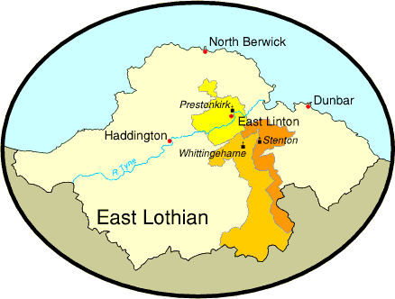
Location of The Former Parishes
The former parishes of Stenton and Whittingehame stretched northwards from East Lothian's boundary with Scottish Borders, through the heather moorlands of the Lammermuir Hills to the arable fields in the north, where they adjoined Prestonkirk with its 7000 acres of prime agricultural land.

 Prestonkirk
  Stenton
  Whittingehame
Back to Location of the Parish of Traprain
Link to Prestonkirk Burial Ground Survey
Link to Stenton Burial Ground Survey
Link to Whittingehame Burial Ground Survey
Page last updated 28th May, 2012
Please contact us if you have any comments about this page or if you have any problems with it.
Home